Great-Circle Route Visualisation with three.js
Over the past few years, as well as learning the Rust programming language, I’ve also been attempting to learn more about the JavaScript ecosystem for front-end web development as well, although the seemingly large number of different libraries/frameworks available has made that a somewhat daunting task in terms of starting point. Because of this, I had decided not to just learn generic and popular web frameworks that were the most popular ones at the time of learning, but to explicitly use ones that seemed to match well with particular use-cases I had in mind.
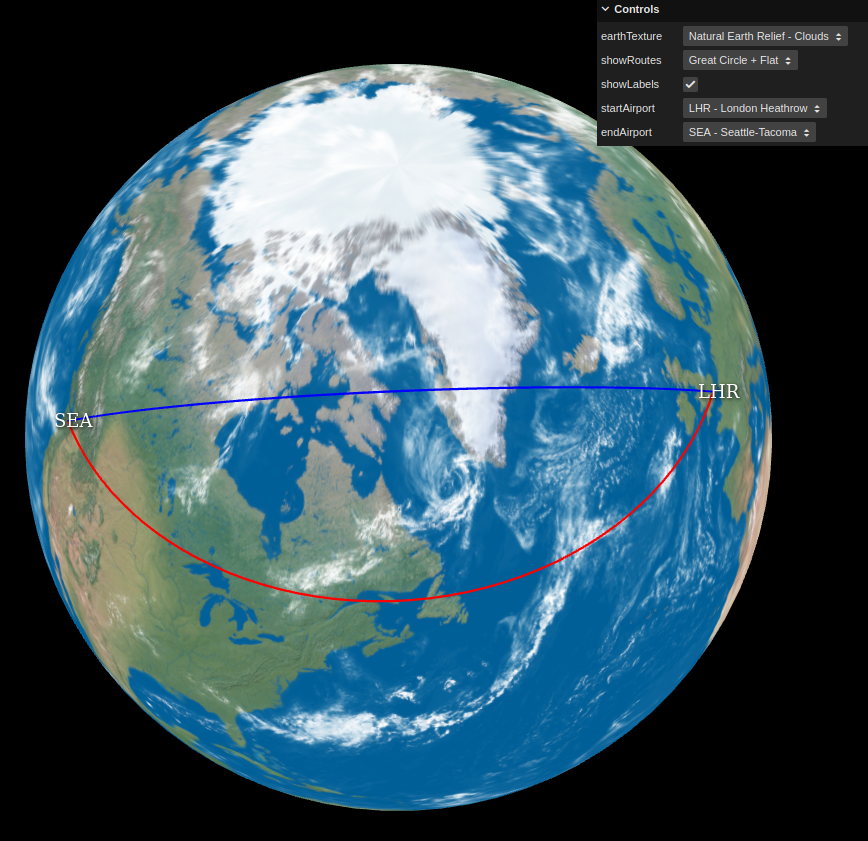
In this case, I’ve been writing a basic web app for visualising Great-Circle Routes (link to app here) between common airports. There are various existing ones on the web in some form or another, but many produce only flat 2D visualisations, and while there are one or two 3D ones showing the routes on a 3D globe, they weren’t exactly to my liking, and regardless, it provided me with an interesting use-case with which to gain some more experience with JavaScript and web-based real-time rendering.
I did at first think about sticking to core vanilla JavaScript and using WebGL directly with no use of additional frameworks/libraries, but given I wanted something working fairly quickly, I decided that using a library would be the more efficient solution, and a quick look at https://threejs.org/ and its capabilities re-enforced that decision.
In the end, it was pretty simple to come up with a basic working example, with a sphere mesh object with a diffuse earth texture on, with an orbit-able camera, with “route” line meshes representing the Great-Circle Route and “flat” 2D route in question being drawn based off spherical coordinates in 3D space from source latitude and longitude coordinates. The Great-Circle Route between two points was calculated by using the Haversine Formula.
The most “complicated” thing in the implementation ended up being the Airport text labels: while it was simple enough to use THREE.CSS2DObject to construct high-quality DOM text items that appear in the correct 2D screen position based off the camera/earth position of where the respective airports are on the sphere, occlusion/visibility handling isn’t done automatically with this setup, as the DOM elements are not actually part of the 3D scene, they’re layered on top. So in order to hide the label text of airports when they’re occluded by the Earth sphere geo (i.e. when they’re around the back of the Earth to the camera), I ended up having to send Raycaster queries to detect the visibility of the position of the airports from the camera, and adjust the visibility of the Airport label CSS2DObject objects based off the result of these queries within the main render loop. This was still quite easy to do however, and seems to work well enough, although doing the raycaster queries within the render loop is probably not the most optimal solution in terms of efficiency, so I might need to look into better ways of handling that.
There’s still room for improvement though: the thickness of the route lines should ideally scale with the zoom level in screen-space, and the fixed colour of the lines means it’s not always easy to see them depending on the Earth texture being used underneath them, so I might have to look into some kind of contrast/blending setup in the future in order to make the route lines easier to see.